Sunday, December 30, 2012

Lake Ontario dunes


Back in early September, I accompanied the sed/strat class at SU on a field trip to the eastern shores of Lake Ontario.
Field trip location marked on a map showing Lake Ontario and New York State.
The field trip was to look at part of a large freshwater barrier beach system that stretches for over 25km along the New York State shoreline of Lake Ontario.
Eastern Lake Ontario, with the approximate extent of the barrier/dune system outlined (the barriers are still visible on the map, immediately right of the dotted line.  The Tug Hill Region is shown for reference. Basemap created using www.geomapapp.org


Our first stop was at Sandy Island Beach State Park, a tiny New York State Park between North and South Ponds. This section of the dune complex is over 1000 years old; most of the sand in the system has been inherited from previous highstands in the Ontario Basin (Woodrow et al., 2012). 
Two topographic maps of the Sandy Pond area: a National Geographic topo map on the left and a USGS topographic profile from www.geomapapp.org on the right, both projected in Google Earth. Click for a larger version.

This beach is sandy, as the name implies, but it also has many well-rounded, hand-sized cobbles, especially just beyond the shore. These cobbles are not from the Appalachian Basin: some of the cobbles were granite, probably coming from the Canadian Shield.
Overlooking the beach at Sandy Island Beach State Park

Sandy Island Beach, looking northeast. 
Three types of sedimentary structures can be seen on the beach: ripples, dunes, and the arced shoreline. These are all bedforms, shaped by the movement of fluids (waves, wind, and currents): the ripples are small wavelength, the dunes are much larger wavelength, and the arc of the beach is the largest wavelength.
A trench dug in the beach (perpendicular to the shoreline) shows low-angle laminations dipping toward the water. Wave action has sorted the sand grains- the darker layers are darker, heavier minerals). 

Grass covered dunes landward of Sandy Island Beach
 From the beach, we met up with a boat that took us across North Pond to the barrier dunes.
Crossing North Pond (looking approximately southeast)
 At the other end of the pond is Sandy Pond Beach Unique Area, accessible only by boat. A boardwalk has been built to cross from the pond-side to the lake-side. This protects the dune from humans and humans from poison ivy.
Dunes with trees! The highest dunes in the area (NOT pictured) are 15m above Lake Ontario.

The beach on the pond-side of the barrier island had some very cool dendritic traces. They were composed of raised networks of sand and were quite extensive. I don't know if they formed on top of the beach like they're pictured, or if a layer of sand covering them washed away. If anyone knows what creature created these, please let me know in the comments!
Mystery trace/burrow. 


The lake-side of the barrier dune complex.

Beach on a barrier island. We were invited to join some beach-goers for an afternoon party, but reluctantly declined. 

I can't remember if this sand profile is perpendicular to the shoreline or not. If it is, the laminations look very different than on the first beach we visited.


The sand has built up inside the channel so much that plants are growing there. Needless to say, it is problematic for boaters trying to get into Lake Ontario.

Birds in the shallow water just inside the channel entrance.

Our boat, waiting while we check out the channel.

This great board explains sand transport to beachgoers. 

*Woodrow et al, 2012 can be found here: http://www.epa.gov/ecopage/ELOSTS.pdf


Monday, October 15, 2012

24 Hours Notice

Accretionary Wedge #50 called for posts about field trip/field camp moments. I'm late posting this, but it means I have an extra story to share...

In mid-September my geomorphology class went on a field trip between Syracuse, New York and Ithaca, New York.

Mid-morning, we stopped at a site not far from Syracuse, where there had been a landslide in 1993. The scar is pretty much grown over now, and there's not much left to see, but we stopped on the roadside to discuss the morphology of landslides. The prof had just finished saying that if he'd called ahead to get permission we could have walked a little way onto the private land to have a look at the humps left behind by the landslide, but he didn't so we couldn't, when a guy rode up on his dirtbike. He was wearing a white muscle shirt, presumably to show off the tattoos covering both arms.  When he reached us he slid to a stop (and almost slid off his bike) before saying we needed to give 24 hours notice to be there. We pointed out that we were actually on the road, and we had no intention of going onto the private land. This went back and forth for a moment or too, before he gave up. Then he asked where we were from. We all suppressed our laughter--we were standing beside a van that had the university and department name written on the side.   Finally he gave up, realizing we weren't doing anything wrong, and rode back down the road to his home. Moments later, the air was filled with the sounds of gunshots, as he and a friend spent about five minutes shooting their guns continuously in an attempt to scare us off (we finished our discussion before we left).

The rest of the field trip was uneventful, making our way south to look at different glacial landforms.  The second part of the field trip was held in mid-October, when we looked at some gorges around Ithaca. We were about to go for a bit of a hike along one trail, when someone in the group noticed the sign saying the trail was closed because it was hunting season. Luckily, another trail on the other side of the brook we were looking at was still open, and we were able to see what we wanted to see.
Glacial valley

Drumlin at Drumlins Golf Course

Guess what we saw on this trail!

Esker (on the Esker Trail)
Ripples!

Stratification in a gravel pit

Imbricated Clasts

Ithaca is gorges
Bedrock joints controlling stream flow

Lick Brook - bedrock incision

Buttermilk Falls - bedrock incision

Buttermilk Falls - bedrock incision

It may not look like it, but this road runs over a drainage divide
Taughannock Falls


Monday, September 3, 2012

Sulphur mining on a volcano


The most eye-catching colour on White Island is yellow, as you can see from the photos below (as I mentioned in a previous post on White Island, the rocks are too corrosive to set scale cards or lens caps on, so none of the photos have scale). It forms crusts around the fumaroles and on the edges of the streams of water. This is the effect of sublimation - the sulphur transitions directly from gas to solid. Inside the fumaroles on White Island there appears to be some liquid sulphur, but I suspect this is caused by re-melting of the sublimate. 

Before I go any further, I want to address the spelling of of sulphur. I am Canadian, and I try to use the Canadian/British spellings of most words (note the 'u' in colour above). The 'American' spelling of the 16th element is sulfur, and this has been adopted by IUPAC. It is the spelling I probably should be using, but I grew up with sulphur, not sulfur, and I just prefer the look of it. There's an interesting post about f vs ph here.

Sulphur is mined for several reasons. It is used in fertilizers, fungicidal plant sprays and the manufacture of sulphuric acid (to name just a few). 

Mining of sulphur began on White Island in 1885. In 1914, part of the crater wall of the volcano collapsed causing a landslide and debris avalanche that killed 12 mine workers. The mining camp on the southern edge of the crater was destroyed and mining operations ceased.

In 1923 mining resumed, but this time the miner's camp was built outside the crater. When the water was calm the miners took a boot to the mine. In bad weather, they hiked up over the rim of the crater and down to the camp. Remnants of the camp and their path can be seen when you circumnavigate the island. The campsite is now occupied by gannets. In the 1930s mining on White Island was permanently shut down because it was not economical. In total, approximately 11200 tonnes of sulphur were extracted from White Island.

Sources:
Moon, V., Bradshaw, J., and de Lange, W., 2009, Geomorphic development of White Island Volcano based on slope stability modelling: Engineering Geology, v. 104, no. 1-2, p. 16–30, doi: 10.1016/j.enggeo.2008.08.003.

Pough, Frederick H., 1988, Rocks and Minerals, Peterson Field Guides, 4th Edition

Emiliani, Cesare, 1995, Planet Earth: Cosmology, Geology, and the Evolution of Life and Environment, Cambridge University Press


The approximate location of the 1914 landslide (orange) and resulting debris flow (blue) that wiped out the  mine and mining camp (gear/purple and white circle). The location of the new mining camp (now a gannet colony) is marked with a red tent.


Sulphur on the ground around a mud pot
Sulphur on the banks of a tiny stream

Fumarole

Close-up of sulphur crystals on the ground. 


Several fumaroles
Steamy


Sulphur on the crater floor
Sulphur in the crater walls

Solid sulphur

Remnants of the 1914 mining operations
Rusted remnants of the 1914 mine

Remnants of the 1914 mining operations

Window to the crater


Beach view from the original mine

Wednesday, May 9, 2012

Auroras

One of the first twitter accounts I started following was @Aurora_Alerts, and it is still only one of two accounts that I have pushed to my phone as text messages.  In the last couple of years, there have been very few times when everything is aligned to see the northern lights from Calgary (51.0775° N): geomagnetic activity needs to be at least "Very Active,"  or close to "Storm"  levels, it needs to be dark, and the sky needs to be clear.

It's not that I've never seen them before. Growing up in Medicine Hat (51.0775° N) we used to see them several times a year. And when I lived in Edmonton (53.5472° N) during my undergrad they were even brighter, and once I even heard them.  One of the first years I lived in Calgary, I saw them dancing away behind the downtown skyline. The thing is, all of this was before I had the right equipment to even attempt to photograph them.

One night, in early March, I was heading to bed around 1am when I got a text about an approaching "storm"  (this was actually a few days before the big magnetic storm that was all over the news). I checked the forecast and looked out the window at the crystal clear skies.

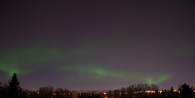
I did what any normal person would do--I bundled up, collected my camera gear, and headed to the park a couple of blocks from home. The park is on a ridge, facing north, and it turned out to be a really good place to watch and photograph the northern lights. Even a coyote thought so (although he didn't appear to have any camera gear with him).

Considering this was my first time photographing the northern lights, I'm happy with the results. For next time, I'll remember that I can't see properly in the dark and I need to find a better way to focus the camera so I don't have a blurry foreground. Even with a tripod and a cable release I should probably stand stiller than I actually did. Lower ISO would probably help too.  But I'll get there (if all the conditions align again before I move too far south to see the auroras).