Monday, October 14, 2013

Seashells, and not at the ocean

I was inspired to write this entry by an xkcd comic:


If you haven't seen this one, the mouseover text is what really made me laugh:  
"This is roughly equivalent to 'number of times I've picked up a seashell at the ocean' / 'number of times I've picked up a seashell,' which in my case is pretty close to one and gets closer if we're considering only times I didn't put it to my ear."
I collected a few seashells in Turkana, in the dry lagas (riverbeds). I was nowhere near the ocean, and I was several kilometers away from the modern lake. But once upon a time...

Lake Turkana is a saltwater lake, and it used to be much larger than it is now.  The photo below is of a rock I picked up en route to our drilling site in northern Turkana. We were stopped for at least an hour because the truck carrying our equipment got stuck. There wasn't anything I could add to the effort to get it out so I had a bit of time to explore the piles of rocks that were carried downstream when water flooded the laga. Because it was found in the riverbed, I don't know very much about it, except that it originated upstream from where I was in ancient deposits.

Seashells that are not from the sea
If you look on the bottom left corner of the rock, there is a darker piece. That's a fish bone.

Saturday, October 12, 2013

#standingwithDNLee

My personal 30 minute blog challenge, in which I spend 30 minutes a day writing blog posts, failed yesterday. I'm not beating myself up for this - I had a research deadline yesterday, and by the time I finished with that I was exhausted and couldn't keep my eyes open for 30 more minutes. 

Today, I'm asking you to take 30 minutes to catch up on what made my twitter feed explode in the last day: censorship used to silence a woman who called out someone for completely inappropriate behavior. 

Begin here, with an account of what happened (including the original post that has since been removed from its home): http://isisthescientist.com/2013/10/11/tell-someone-no-get-called-a-whore-standingwithdnlee-batsignal/

Then these posts which call out Scientific American for their appalling action (hopefully the ones hosted by Scientific American won't also be censored):


And finally, here, for a call to everyone to join in and "raise our voices":

Thursday, October 10, 2013

Look up!

I've posted before about the importance of looking up and around when you're out in the field. In 2012, on a field trip that crisscrossed a remote corner of Dinosaur Provincial Park and some of the private land surrounding it, I took the following two photos.

The red arrow in the top photo is pointing to my scale card, which has 1 cm markers on the right side.  This scale card is as high up the exposure as I could reach.  The blue arrow is pointing to some eroded but still cool cross-bedding.  And above that is the really cool reason to look up.  A dinosaur bone.
High up in the badlands. The scale card at the bottom is in the highest nook I could reach.
The bone is still there because this is a remote area that you need permits and permission to access. It's possible it has only recently been exposed, and I overheard field trip participants talking about how they could climb up to get it down to take home. Fortunately, they were ushered on before they could carry out their plan.  Because of the nature of the southern Alberta badlands, they wouldn't be able to find it again if they went back on their own either. 

A closer look at the dinosaur bone. 


Wednesday, October 9, 2013

Hillshades of New York State

I've always been fascinated with maps. At some point in my teenage life I thought it would be amazing to be a cartographer.  I do make a lot of maps for my research, and it's one of my favourite things to work on. I've been spending a lot of time lately working with DEMs (digital elevation models) and using them to create hillshades, like the one below. 

New York State is a great place to study glacial morphology, and this hillshade, which shows a bit of Lake Ontario at the top, all of Seneca Lake (bottom center) and some of Cayuga Lake (bottom right), is a great example of why. 

Just south of Lake Ontario there are many tiny hills. These are drumlins, remnants of the last glacial period in the area. The Finger Lakes (of which Seneca and Cayuga Lakes are the largest) are deeply carved valleys that filled with water when they were dammed by terminal moraines of the Pleistocene Glaciation.  At the far southern end of the map, the terrain becomes more rugged. This is the northern extent of the Allegheny Plateau.

For more posts about drumlins, check out Evelyn's Geology Word of the Week, where she writes about Drumlins and posts links to other posts.

The other thing that is great about studying in New York State is the availability of geospatial data for the state. Cornell University, through its CUGIR site, offers "open and free access to geospatial data and metadata for New York State."  This was immensely helpful for the geomorphology project I wrote about yesterday, and for preparing resources for the sed/strat field trips I've been TAing this semester.

Hillshade of the Seneca Lake region in central New York State

* This post is part of a personal challenge I've made to spend 30 minutes a day on my blog. For this week, I'm trying to get out short posts every day. 

Tuesday, October 8, 2013

Field Fridays

Last year at this time, I was spending my Friday afternoons in Morgan Hill State Forest collecting data for a geomorphology field project. My objective was to determine the controls on stream morphology in one valley using field observations.

Left: The study area, in New York State. Right: Morgan Hill State Forest. The study area is the purple rectangle within the State Forest. 

Morgan Hill State Forest is 5294 acres. Once farmland, the land reverted to the state when the farms were abandoned and between 1929-1931 the land was planted with conifers and native hardwood.

The streams in the study area flow into the eastern branch of the Tioughnioga River, eventually reaching Chesapeake Bay via the Chenango River and the Susquehanna River.

A lot of my field work involved walking the study area with a GPS unit, collecting waypoints and tracklines to go along with my observations. I made four transects of the valley to get elevation profiles, walked along two ridges, walked along the streams, and  measured stream orientation at several locations to correspond to the one set of bedrock fractures that were visible in the study area.  It was definitely very rudimentary data collection, but it was enough to get a sense of what was going on in the valley.

I did some statistical analysis on this data as part of a project for a statistics class, and it was great to have the opportunity to go into more detail on the quantitative assessment of the data I collected and its precision.

Left: Data collected with a handheld GPS unit. Large circles are waypoints; smaller circles are part of the recorded tracks. Right: The locations of the four transects used to create elevation profiles, the mapped stream locations and orientations (arrows) and the bedrock orientations. Downstream is to the south.

What I loved about this project was that I got to choose my field area (from one of three possible sites) and decide what to do with it. I learned so much from this study!  Field equipment was limited, because the entire class had to divvy up what was available, so I also had to think about what I could do with the equipment I had. If I was doing the same project again, with the same equipment, there is one thing I would change. I would have walked each track and each route several times so I could average GPS data (lat, long, elevation) and try to increase precision.

My field observations suggest there is a relationship between stream orientation and bedrock fractures. This is assuming that the one exposure of fractures (two sets though) is representative of all fractures in the region. The mean orientation of the stream, calculated from the collected orientations shown in the map above, is equal to the orientation of one of the joint sets.

The stream beds were covered in pieces of shale, and in some places they were even imbricated. My interpretation was that these shale pieces were once part of the bedrock but they've been broken up and moved by streams, particularly during spring runoff. Over time, this process widened the valley upstream (see figure below). Downstream, the valley narrows, interpreted to be caused by incision of a more resistant rock than the shales upstream (although not confirmed because the edge of my study area was also the border of the state forest and I didn't want to go onto private land during hunting season). This produced the ridges/terraces observed at the south end of the study area.

Elevation profiles for the four transects are shown on the left. 5m contours have been added to this map to show the general valley morphology. Recorded elevations for profile C-C' are higher than those upstream and downstream. Contours were not draw through this portion of the map to reflect the uncertainty in this data (this transect was collected when the Garmin battery was low). Downstream is to the south.
This project was definitely my favourite part of any of the course work I've done for my PhD. Not only did I learn a lot, but it was great to see fall developing in the valley over the course of the "field season."


Photo 1 taken at waypoint 017. Photo 2 taken at waypoint 060. Photo 3 taken at waypoint 045. Photo 4 taken at waypoint 051. Waypoint locations are shown on the map above.
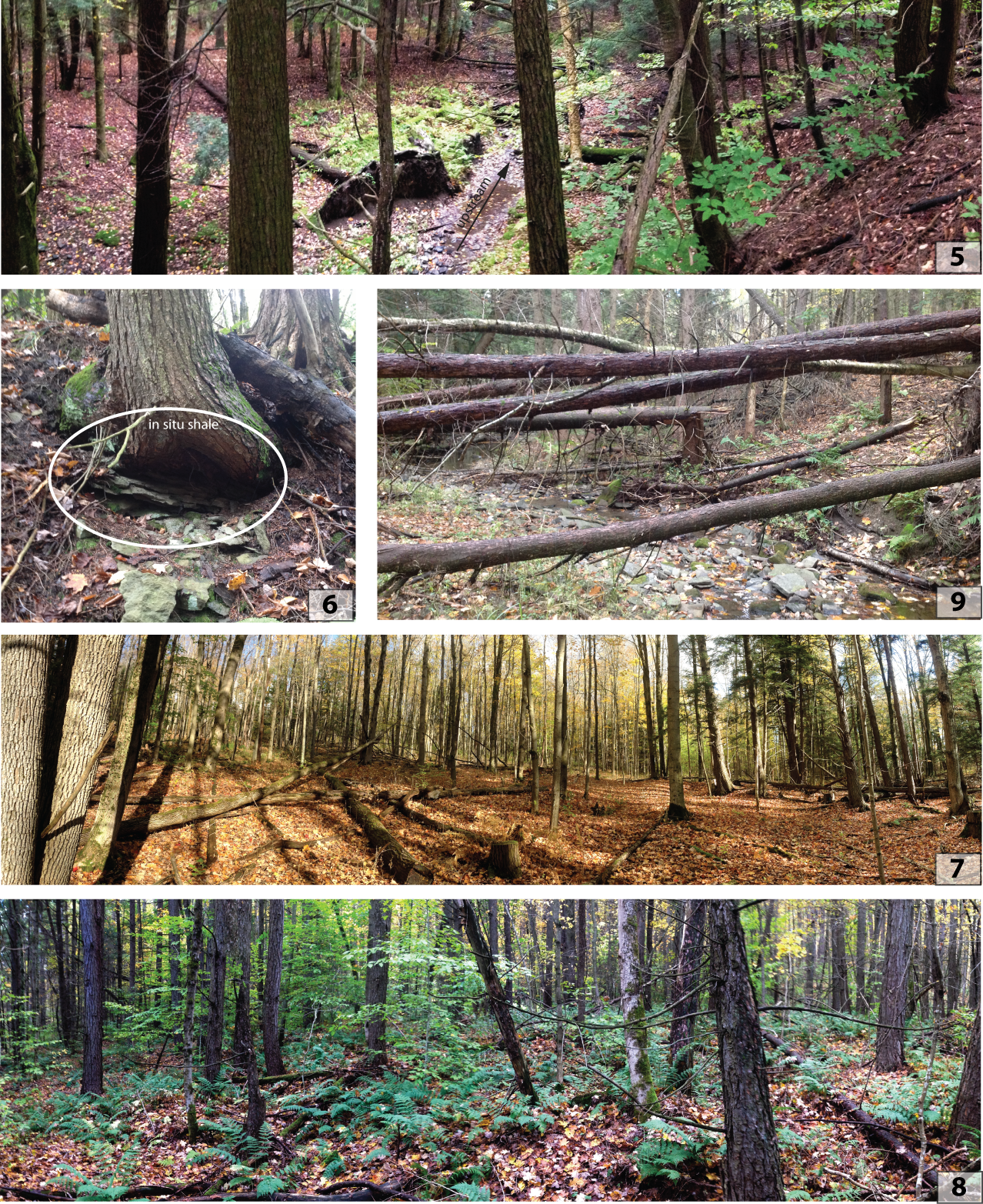
Photo 5 taken at waypoint 022 (standing on ridge). Photo 6 taken at waypoint 047. Photo 7 taken at waypoint 065. Photo 8 taken at waypoint 042. Waypoint locations shown on map above.
* This is day 2 of my personal "30 minute blog challenge," where I'm dedicating 30 minutes a day to my blog. This post fit into the 30 minute time frame because all the figures were already done for my report.

Monday, October 7, 2013

Ringing Rocks

On a hill above the Delaware River, on the Pennsylvania side, is Ringing Rocks County Park. The closest town is Upper Black Eddy, just east of the park. In October 2012 I had the chance to visit this park as part of a Newark Basin Field Trip run by Roy Schlische and Martha Oliver Withjack of Rutgers University.

A short walk from the parking area leads to a boulder field. On Google Earth images, this boulder field really stands out among the trees. The boulders are diabase, and some of them ring when hit with a hammer. You can hear it yourself in this video:


The Coffman Hill diabase, found at Ringing Rocks, is near a border-fault margin of the Newark Rift Basin.  The reason for the ringing isn't well understood, but the origin of the diabase is. The surrounding area contains shallow lacustrine deposits of the Triassic-Jurassic Passaic Formation. These rocks were intruded by diabase sills and dikes associated with the Central Atlantic Magmatic Province (CAMP) and the breakup of Pangea.
The location of Ringing Rocks County Park, on the Pennsylvania side of the Delaware River. The town of Upper Black Eddy is just out of the picture on the right.

The boulder field at Ringing Rocks County Park.


* In an effort to get back into blogging, I've created my own 30 minute challenge: every day I want to dedicate 30 minutes to blogging. This will start out as short, but more frequent, daily posts like this but I hope to transition to slightly more detailed posts a few times a week.