Tuesday, April 30, 2013

Folds!

This week is crazy-it's the last week of classes and I'm getting ready to head to a conference next week so I don't have time for a longer post.
Here's a quick picture of a rock I collected on a field trip this weekend from an outcrop just west of the MA-NY state line near I-90. The rocks there are part of the Taconic Allochthon. Some day I'll post more about this field trip.

This sample is 2-3 inches wide, depending on where you measure it.

Friday, April 26, 2013

Whiteboard-fest

It's Mayfest.  Mayfest is the day when the undergrads at SU celebrate the end of the school year (next Tuesday is the last day of classes). It involves cordoning off some of the streets near campus, a big concert in the Carrier Dome, and of course, libations.

As a grad student, I'm not celebrating Mayfest. Been there, done that (we called it end-of-year Beer Gardens where I did my undergrad and it was Bermuda-Shorts-Day (or BSD) where I did my MSc).  Plus, I don't have the time for it right now. With classes wrapping up I'm swamped with assignments and exams. I'm going on a field trip this weekend (studying the Wilson Cycle in New England) and next weekend I leave for ten days in Canada to attend and present at geoConvention and visit my family.

So I've spent this sunny Friday afternoon in an empty classroom working on my dissertation proposal (or at least the proposal for the first chapter).  I've already done preliminary work on this chapter as part of an Independent Study last term, and earlier this month I put together a (winning) poster on that work for a local student symposium.  So I've spent a lot of time looking at existing maps of my study area in the last few months.

Recently, I've been struggling to write up the literature review, and tie in what I'm learning about the overall East Africa Rift System with the data I'm looking at in Lake Malawi. Trying to come up with questions to answer that are meaningful (a.k.a. hypothesis testing) is hard.  So today I decided to try to make my own sketch on the whiteboard.  I use whiteboards like Dumbledore uses pensieves.

And in the process of reproducing the fault map I've been staring at for months (that I've even re-traced in Illustrator), I discovered something I'd missed before.  Something important to understanding the evolution of  "my" accommodation zone.

This is really cool to me, and at the end of a long, hard semester of classes, I'm really excited to have a new perspective on the work I'll be doing over the next few months. I feel much better prepared to finish writing my proposal now too.

In other words, to really understand geology, you need to make your own schematic sketches. They can be on whiteboards, on napkins, on envelopes (although you may want to save the back-of-the-envelope for any math you need to do).  It doesn't matter where you do them, but sketching things out is a great way to understand geological relationships!!!

My whiteboard sketch.  The big black "boxy" things are border faults on two oppositely-facing half-grabens. The green dashed lines represent three segments of the accommodation zone between the two half-grabens (they are accommodation zones within the overall accommodation zone marked by the blue dashed line). I'm studying the accommodation zone in the middle-left.  What I've missed up until this afternoon is that there is probably a close relationship between it and the fault that bounds the mini-accommodation zone below and to the right.

Tuesday, April 23, 2013

A call to action for (the day after) Earth Day

I'm just over eight months into my PhD and my new life in America, and lately I've been spending a lot of time thinking about the choices I've made in the last few years to get here. I also think about the choices I make here, every day. I think about the choices we, as earth scientists, make in our day-to-day lives.

Flamingos at Laguna Colorada, Bolivia

Geologists (and other earth scientists) are a fortunate group. We get to spend time outside doing research in amazing and remote places. I know I'm not the only one who has seen amazing and inspiring places and met wonderful people through science.

Bolivia 

In 2009 I had the chance to do field work on the Bolivian Altiplano. Amazing geology, amazing landscape, but a hard place to live. We encountered suspicion from the locals who were afraid we were going to profit from some hidden resources and leave them impoverished. Most were welcoming once we (through our driver/translator) explained that we were just scientists. But still, they asked us for help. They needed help finding water. In one village, we were given one room of a family's mud-brick house to cook in. I cooked off of our gas stove on a dirt floor, the only source of light coming from a tiny oil lamp they loaned us. The water we used for cooking was hand-drawn from a well.  On the day we left, electricity was being installed in a few of the homes, so that they would have better light.

Laguna Colorada, Bolivia

More than the incredible places I saw, it was the life of the locals that has stayed with me.  Wherever I end up when this degree is done, I will not be satisfied if I am not finding some way to help others. This could be through public outreach, through volunteering, or through teaching. I'm figuring that out as I go, but I feel a responsibility to make a positive contribution to the world that I live in.

The edge of the Altiplano, Bolivia

So how does this tie back to Earth Day, and to all earth scientists?  As earth scientists I believe we should be leading the way in making sustainable choices on a day-to-day basis. These choices do not have to be big ones (not everyone can afford the upfront cost of a hybrid). But there are lots of simple things we can do.

Bolivia

In a building full of earth scientists I've seen people throw soda cans and cardboard in the garbage because it is closer and more convenient than the recycling bin on the other side of the room. I've seen soda cans in the garbage bin right beside the recycling bin.

Arbol di Piedra, Bolivia

The call to action, my challenge to you, is this:  think about the small choices you make every day. Show, through your daily choices, that you want to preserve the earth.

Don't use bottled water when there is potable tap water available.

Get yourself a refillable water bottle and use it. Keep one at home and one at work.

Coffee mugs? Keep one on your desk and take it with you when you go down to the coffee shop during the day (you might even get a discount on your java).

Think about packaging when you're doing your shopping, especially groceries. If you can choose a product with less packaging, do it.

When you leave a room, think about whether you need to leave the lights on or not.

Make sure that every choice you make (not just the ones I've suggested here) favors sustainability. Not because the world will collapse if you don't, but because it's just the responsible thing to do.

Sunset at Laguna Colorada, Bolivia

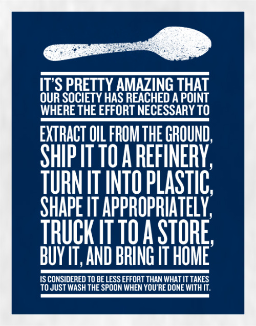
I could end this post with any number of cliches, but instead I`ll finish with this "poster" that began circulating the Internet a while back. Don't get me wrong, I'm not trying to shut down the petroleum industry. I don't think we can live without it. But we don't have to be stupid about it.

http://maxistentialist.tumblr.com/post/4174573186/prints-available


Monday, April 15, 2013

Building a field guide

As I mentioned in my last post, every participant on our field trip was responsible for creating one section of our field guide, and I compiled it all in the end. It was a bit of a non-traditional way of doing it, and more than a bit of a challenge to get everyone to participate in a timely manner and there are things I wish I'd organized differently. However, we ended up with a 55 page field guide and I hope that people felt a little more engaged with the geology!

The first step was dividing up the stops. Death Valley was simple to divide up, but Grand Canyon was trickier. Once the Death Valley stops were divided up, there were four people left to cover Grand Canyon.
I found an old strat column for Bright Angel Trail (which was where we were going) and split it into four, but looking back, I think it would have been even better to divide it up with one person focusing on the basement, one on the unconformities, one on the stratigraphy, and one on faulting (and/or the Colorado River itself).

The details about what I needed from each person, in terms of materials etc., went out in an email. This is one of the things I wish I'd done differently. I should have created a pdf instruction sheet that I could email out and post online for people to reference.  It would have contained exactly the same information as the email, but it would have been easier to find and reference.  The details I wanted are below:


Geological information that should be included is:
-          The age of the rocks
-          What the rocks are (composition, stratigraphy, depositional environment etc)
-          Any subsequent deformation they have undergone.
-          Tectonic framework – how does this fit into what’s happening in the region (and in the case of Death Valley, the basin).

Things to consider including are:
-          Annotated photos
-          A stratigraphic/time column for the section
-          Schematic illustrations/maps
-          References (peer-reviewed references if you can find them)
Any figures/maps/photos should have correct citations and detailed captions.                               

Ultimately, I wanted people to explain what was cool about "their" stop, and why we, as geologists, should care.

I wasn't specific about formatting in my email, which was my next mistake. I should have created a Word template for people to use, and my instruction sheet should have been explicitly clear not to embed photos/figures in the document, but to attach them as separate files so that I could do all the formatting for all the pages, and it could be consistent.  

The other trick to putting this together was that the itinerary was out of my hands, and was only ever tentative at best. Still, I wish I had spent some time putting together info about the places we would be driving by (we had as many driving days as we did geology days), especially on the first day when we drove from LA, over the San Andreas Fault, to Death Valley (see my previous post for a few photos from that day).  Even if we didn't get out of the vehicles, it would have been nice to understand what we were driving by!

We did have stops on our other two driving days, at Hoover Dam and at Meteor Crater, which were included in the field guide, so there will be posts about them to follow, along with all the other places we stopped.  Stay tuned... I'll start blogging about Death Valley itself next.

Monday, April 8, 2013

Southwest Field Trip: Getting There

Over spring break, the SU Geology Club organized a field trip to Death Valley and Grand Canyon. We had an amazing week, and I have quite a few things to blog about from the trip, but first we had to get there...

We flew from Syracuse to  LA (via DC) on Friday night, and after a few hours in a motel, we got our supplies and hit the road, crossing the San Andreas fault, past Red Rock Canyon, crossing Panamint Valley before arriving at Stovepipe Wells Campground for our first night. It was a long day, and we didn't stop very often, so most of my photos were shot through the van window as we went.

Red Rock Canyon

Red Rock Canyon

Rest Stop and Gas Station in the Mojave Desert

Father Crowley lookout

@ Father Crowley point

Crossing the Panamint Valley

Late afternoon sun

View from Father Crowley Point
Since we didn't have a field trip leader who had spent a lot of time in either area, we decided to split up the organization of the field guide and the "teaching" at each field stop.  Once we had a working itinerary, the stops were split up so that each participant on the trip (14 students, both grads and undergrads) was in charge of researching and putting together notes on a specific locality.

My next blog post will be more about putting the field guide together - what worked, what I wish we'd done or done differently, etc.  In the meantime, below is a video I put together with snapshots and video from the trip (including video of driving through the volcano just east of Father Crowley Point), showing everywhere we went and giving credit to each student's contribution to the field guide.

    
Southwest Trip, Spring Break 2013 from Tannis McCartney on Vimeo.