First, let me start with a disclaimer: I am not a volcanologist. I do, however, think volcanoes are cool. And you don't have to be a volcanologist, or even a geoscientist, to have an awesome and amazing time on the
day-trip out to White Island.
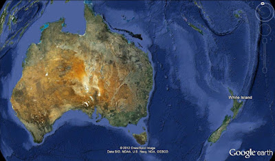 |
| White Island is in New Zealand's Bay of Plenty, shown on the left side of this image. |
It was a gorgeous September day in the Bay of Plenty when I went on my tour. It was the off-season, so the boat wasn't full and there was no rush to get back so they could run two tours in one day. Which was awesome because on the ~80 minute boat ride from Whakatane to White Island, just as we were tucking in to morning tea, we saw a small pod of orcas. The boat stopped, and we got to spend about 20 minutes watching them. At first there were three (mum and two little ones), but then the bull came up. Instead of herding his family away from the boat they stayed. Probably because we were right over a reef where there was good food. In fact, every once in a while one of them would come up with a fish in its jaws.
 |
| This one just caught something to eat. |
Once we left the orcas behind, I started focusing on the volcano on the horizon. It was steaming, as it always does. In fact Captain Cook named it White Island because it was always surrounded by clouds. He never got close enough to see that it was actually a volcano.
We anchored in a little bay, were handed our hard hats and gas masks, and were ferried to the dock on a zodiac. The colours on White Island are spectacular, especially in contrast to the water and the sky behind.
 |
| On the horizon you can see the mountains of the Eastern Bay of Plenty |
White Island is an andesitic stratovolcano, and it is New Zealand's most active cone volcano. It has recorded continuous activity for 150000 years. The most recent eruption was in 2000. It is continuously monitored, and the tourists can't go out there if there is any risk of an eruption. In fact, one of the first things you see when you start the walk around the crater is the wire coming over the crater rim that leads to a drum containing a seismic monitoring station:
 |
| Arrows are pointing to the cable, and the drum is circled. |
White Island has two overlapping craters. There is a lake in the center of the central crater. The crater lake appeared during an extensive period of eruptions in the 1980s, and moved during the 2000 eruption.
 |
| The overlapping craters. The boat lands in the little bay where the anchor is, on the edge of the older, eastern crater. The central crater is sometimes subdivided into sub-craters. |
The tour goes around the west side of the smaller crater, and a little bit into the central crater before crossing to the east side and coming back. The crater walls are a bit unstable, due in part to the fact that they are hydrothermally altered. The water on White Island has no connection to the sea, so no other water gets in or out. Instead, the water is recycled over and over again. This means that everything on the island is very corrosive--the tour guides "burn through" about one pair of shoes per season. Unfortunately, this makes it really hard to put objects for scale into the photos.
There are several mounds on the crater that look like they would be fun to climb, except they are fragile and hollow. Underneath them are steam vents and/or boiling mud--not something I'd like to fall into!
 |
| One of the mounds on White Island |
 |
| A close-up of one of the vents on the mound pictured above |
 |
| The kind of thing that is underneath the mounds |
 |
| Over time, these holes get bigger and bigger... |
White Island contains a few fumaroles. As you can tell from the colour, there's sulphur here!
 |
| Close-up |
 |
| A bit further back, but still the same fumarole as above |
 |
| A wide-angle shot of the same fumarole |
The crater lake isn't always visible when you're on White Island. Whether or not you can see it depends on which direction the wind is blowing all the steam in. We waited for at least five minutes and were lucky enough to get a quick change in wind direction--enough to see part of the lake. The pH of the lake is about 1, and the temperature of the lake is about 50C.
 |
| Approaching the crater lake. |
 |
| The view at the rim of the crater lake. |
 |
| The crater lake. |
Tours only go if the weather is good enough to hike around the crater for a few hours, and to get to and from the island safely. Sometimes three, four, or more days will go by between trips to the island, and the guides never know what changes will have happened in the meantime. New holes can open up on the crater floor, requiring that the path be moved.
 |
| A new hole, right in the middle of the former path. |
I'll have at least one more post about White Island coming up...


